

Uncharted ARCTIC CANYONS
Summary
This is a multi-video series with 5 parts. They can be found here: Arctic Canyons Episodes
Want more info? I did a 2 hour interview about the trip: Tuktut Nogait – Canoehound Outdoor Adventure Show
This summer, I embarked on an 11 day, Solo, Arctic Packrafting and Hiking Expedition in Tuktut Nogait National Park. Easily one of the most incredible places I have ever been to, and it doesn’t even seem real when you are surrounded by the canyons. This is a very remote area, well over 200 km north of the Arctic Circle. To give you an idea of how few visit, in 2023, the park had a single visitor, and it was me. I worked with the park and researched for over 2 years to put this trip together. My mandate: I would traverse, chart, and paddle the Hornaday River through the Canyons to the Arctic Ocean.
Here is my overview route map. For a detailed map of the river canyons, as well as my gear list, and additional info, click the link above with the wrench.
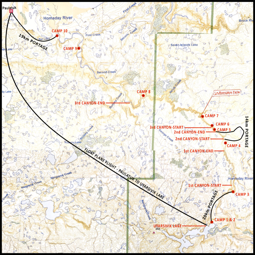
I was flown in from Paulatuk to Uyarsivik Lake, compliments of Parks Canada (which is an awesome story for another time), and spent the first 2 days at an Inuvialuit Camp where youth was being taught skills and history by their Elders – it was a very humbling experience to see how one can live off the land. It then took me 10 days to get from Uyarsivik Lake to the Arctic Ocean. There are 3 very long white water canyons spanning this section of river. They are highly committing, with the longest being the 3rd canyon – I spent almost 4 days making my way through it. Lots of scouting, consistent back to back sections of rapids and portaging is very difficult on the rock walls.
It seems that the animals do not fear humans here. There was wildlife galore, every day in the valley had Caribou around me, a wolf in camp, and a grizzly at the side of the river while I paddled (very quickly) by. He came to the rivers edge to investigate, and lost interest and trotted up the river bank.
A little history of the trip, I was scanning for canyons in Northern Canada on google earth and came across this park. It was clear there was a very aggressive and long canyon section cut right in the arctic tundra. I spent months researching and found that this section of river was first attempted in 1977 by Larry Osgood and his team. They were successful in paddling a good portion of the canyons, portaging out of the canyons when needed. I acquired a copy of his journal (54 pages) of this trip, and I can’t even imagine the challenges of such a trip with the gear that was available and the lack of maps and information that there would have been at that time. Then, in July of 1999, the Beaudry Team, comprised of professional kayakers along with Parks Canada, became the first and only full descent of the Hornaday Canyons. They successfully ran the entire river and their report, albeit much shorter, had very good data in terms of the canyon descriptions. This section of river then lay dormant for nearly 25 years….
That is…until me and my packraft made our way up there! I filmed and documented every rapid, portage, campsite and point of interest along the canyons. I created a map (which is too large to upload here but will be hosted on my website) so that others can have the opportunity to safely run this incredible river.
The video linked above is the trailer for the multi-part series that is starting November 1st. If you have seen any of my other trip videos, this one will be the same, basic documentary style go-pro footage stitched together with some music here and there. I’m not a super fancy editor, priority is always the trip itself. Enjoy!
So you want to visit the park? Then keep reading!
Tuktut Nogait Hornaday Canyon Trip Planning Information
This information was specific to my trip and itinerary, yours may differ depending on the intended route.
Getting there:
The jump off point for my trip in Tuktut Nogait National Park was Paulatuk. This is a small community of about 300 people living on the shores of the Arctic Ocean, and can only be accessed by Air from Inuvik. A multi-day hike will bring you to the park border.
You will easily be able to find commercial flights to Inuvik. From Inuvik you can use Aklak Air to fly to Paulatuk.
There are options to fly in direct to various areas of the park from Inuvik and Norman Wells using a float plane charter. These tend to be much more expensive.
Paulatuk:
There is a hotel inside the Paulatuk Community center and an AirBNB in the town of Paulatuk. Prices are around $250/$300 per night. This is a small community, you are able to walk to everything in town.
The Gates of the Hornaday Canyons
You can hike directly from Paulatuk to the gates of the first canyon. This is roughly 70km over arctic tundra. The trip will give you an opportunity to scout the entire length of the river from the canyon rim. I was flown by floatplane from Paulatuk to Lake Uyarsivik, from there it is a 15-20km hike to the gates of the 1st canyon.
Hornaday Canyon Map
The only map of the river that I know of is the one that I made. This will contain all the information needed for your trip from the gates of the 1st canyon, to the exit of the lower 3rd canyon. You will need to obtain any other maps for hiking and traversing the lands. There are a few companies offering maps of Tuktut Nogait National Park, just search online.
Permit
A permit is required for a trip into Tuktut Nogait and it is issued by the park. Keep in mind that the permit process is not the same as your local parks. They will want to see a resume of sorts including your gear, an accurate trip plan, to ensure you are qualified for the trip you intend to take. The requirements are decided by the park and will depend on your intended route and activites. This can all be obtained from the park, but be prepared to potentially show things like private rescue insurance, certifications related to paddling and climbing skills, and any other safety and rescue plans that they may want to see.
I am not able to personally help you obtain a permit in the event that it is declined. You must work with the park and the community to construct a trip that they approve.
Flexibility:
It is best to be very flexible with your plans. I had planned to go in the summer of 2021 and the park closed the canyons to the public for the year. In 2022 I cancelled my trip days before my planned departure date and the water levels spiked so high the canyon could not be paddled. In 2023, I was finally able to go to the park and the water levels ended up being quite low.